top of page

A Complete Hiking Guide to Cerro Morrogacho in Salento, Colombia

4.6377° N, 75.4891° W

Foggy, gray forested mountain in Colombia

EVERYTHING ADVENTURERS NEED TO KNOW ABOUT HIKING THE STUNNING CERRO MORROGACHO IN COCORA VALLEY, SALENTO, COLOMBIA.


If you have looked at any photos of Colombia, it is very likely you have seen at least a dozen photos of tower palm trees in a verdant green valley. While the whole landscape might seem a bit Dr. Seuss-ian, in fact, that place totally exists (actually a couple of places like that exist in Colombia).


Cocora Valley, or Valle de Cocora, is supposedly the second most visited place in the whole country (after Cartagena's Old City). While the place is absolutely beautiful and definitely worth seeing, it is also a bit of a madhouse, especially on the weekends and during the holidays. We have been lucky to visit a couple of times while living in Salento (the closest town to the valley) and have done numerous hikes in Cocora Valley.


And while the whole Cocora Valley Loop Trail is magical, we instead recommend maybe getting a bit more off the beaten path and taking on the Cerro Morrogacho Trail.


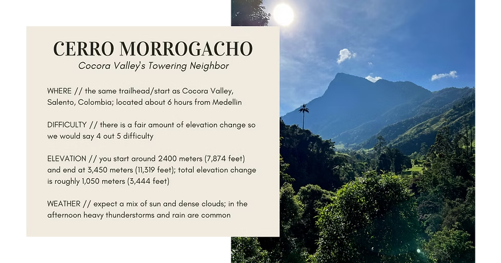
Cerro Morrogacho, which translates very roughly to slouchy nose hill (cerro = hill, morro = nose and gacho = slouchy/droopy) is the prominent mountain that stands along the right side of Cocora Valley. It is easily seen from almost all sides of the valley, including from the main touristy area (near the restaurants) and even as far away as the mirador in Salento.


If you want to get a totally different perspective of Cocora Valley and its famous wax palms, or you just want to take on a more challenging and off the beaten path Colombian hike, then this is the trail for you. Below is everything an adventurer needs to know about trekking up Cerro Morrogacho; including, the total distance, how to reach the trailhead and what to see along the way.


Quick guide to hiking Cerro Morrogacho in Colombia


HIKING CERRO MORROGACHO IN COLOMBIA


\\ Why Hike Cerro Morrogacho


Sitting proudly on the edge of Cocora Valley, one of the most popular tourist sites in all of Colombia, Cerro Morrogacho is a fantastic hike to do if looking to experience the beauty of Cocora - and its famous wax palms - without all of the crowds.


Plus, along the way, you also have the chance to hike through some truly stunning landscapes. Including, dense jungles full of moss-covered trees, ridges with flowers that look like ocean coral and open meadows with cackling parrots. And if you are really lucky, you might just get a stunning view of the surrounding mountains - including Nevado del Tolima - from the very top.


While you do feel like you are totally alone while hiking Cerro Morrogacho, in truth, you are only around 6.4 kilometers (4 miles) from the main Cocora Valley area. Similarly, along the trail up to the top, you also pass two fincas and a refugio (which may or may not be abandoned).


Altogether, hiking Cerro Morrogacho is a great way to experience the famous Cocora Valley - while also exploring a stunning jungle-mountain landscape that is full of animals and almost no people. The hike, in our mind, truly checks all of the boxes a grand adventure.


💡 GOOD TO KNOW: this hike does not technically go all the way to the very top of Cerro Morrogacho but instead to a mirador a little farther down. But there is actually not a clear trail to the very top of the mountain and the mirador is the main endpoint for all hikes up Cerro Morrogacho. Plus, there is a nice wooden sign at the mirador that states the elevation (3,450 meters / 11,319 feet).


ENTRANCE FEE


While there are two places you have to pay while hiking the famous Cocora Valley Loop Trail, you actually do NOT have to pay to do the Cerro Morrogacho trail. In fact, a good way to know you are on the right trail is if you get to the first pay station on the loop while going counter-clockwise, you have gone just a bit too far.


💬 INSIDER TIP: if you are a bit confused about where to start the Cerro Morrogacho trail, head to the pay station and ask the attendant. They will point you in the right direction.

The only thing you will need to pay for when trekking up Cerro Morrogacho is the Willy ride to Cocora Valley. This 15-minute ride costs 4000 COP ($1 USD // €0.90 Euros) per person, each way. Therefore you will need to pay 8000 COP ($2 USD // €1.80 Euros) total to go to Cocora Valley/Cerro Morrogacho and back. You will pay for the whole round-trip ride in Salento.


\\ Where is Cerro Morrogacho


Cerro Morrogacho is located right on the edge of the famous Cocora Valley, home to the tallest trees (the wax palms) in the world. The mountain is easily visible from the Cocora valley “town” - where you will find many restaurants, touristy photo spots and horse tours.


The closest town to the mountain is Salento, Quindio, which is located about 15 kilometers (9.3 miles) away. In fact, the mountain is so prominent in the entire Cocora Valley (not just where the palm trees are) that it is easily visible from the main mirador in Salento.


Lit up jungle canopy in central Colombia


HOW TO GET TO CERRO MORROGACHO


To get to the Cerro Morrogacho trailhead, you simply need to follow the same route as you would to reach the famous Cocora Valley. This means taking a Willy (the big colorful, WWII-era jeeps) from the main plaza in Salento, Colombia to the parking area in Cocora Valley. This is about a 15-minute ride.


Once you get to Cocora Valley, the Cerro Morrogacho trail is easily reached by heading out on the same trail as you would to do the Cocora Valley Loop counter-clockwise. Simply head through the blue gate near the Willy parking lot and down the dirt road towards the trout (trucha) ponds. From there, keep walking until you see a smaller road heading off to the right towards a finca. This is the start of the Cerro Morrogacho hike. Altogether, it is probably a 5 minute walk from the main paved road in Cocora Valley (where the restaurants are) to the actual start of the trail.


You can find the entire, in-depth hiking trail route guide below.


MAP OF COCORA VALLEY + CERRO MORROGACHO


MAPS


For the first time (maybe) ever, we found ourselves unable to use our usual off-line mapping service, maps.me. Instead, we had to rely on a mix of Alltrails (to give us an idea on the start of the hike), Gaia - another great offline map - and our own intuition. Luckily, the trail, once we found the start of it, was very easy to follow.


We recommend having some form of offline map handy during the hike, just in case you need to orient yourself while trekking up to Cerro Morrogacho. In our experience, we found Gaia to be the best mapping service - though even that one didn't have the full map available.


🗺 If you want to download our mapped route - which shows the exact elevation change and hiking path up to the top - then subscribe to Backroad Packers.


\\ When to Hike Cerro Morrogacho


This hike is totally doable year-round since the weather doesn’t change very much. But in our opinion, the trail conditions would likely be best in the dry season when rain is a little less common and you can expect very little mud.


We did the hike in the middle of the dry season and found the conditions to be really nice. We had sun in the morning and then clouds came in during the afternoon. While we did hear rumbles of thunder around 2 PM it never ended up raining on us. We expect that is not always the case, so like most mountain hikes, the earlier you go the better.


CERRO MORROGACHO | THE ADVENTURE BREAKDOWN


TOTAL DISTANCE

~ 13 kilometers // 8 miles round-trip; 1,147 meters (3,763 feet) of elevation change (climbing) from the start of the dirt road in Cocora Valley to the end of the trail (the mirador).


TIME NEEDED

6-8 hours total; it took us 4 hours up and around 3 hours down - but we also stopped a number of times to capture time-lapses of the fog and to get photos of the plants and animals. We would say that if you were really pushing it, you could likely do the whole hike in six hours.


Bright mountain landscape in central Colombia


\\ The Ruta | Basic Hiking Route Breakdown


START: the trail actually begins at the same spot as the Cocora Valley Loop if going counter-clockwise. This means heading out on the dirt road through the blue gate next to the main parking lot where you get dropped off and picked up by the Willys.


1. Head down the dirt road, past the trucha ponds (trout) and a small wooden bridge until you see a smaller dirt road heading off to the right. There will be a sign saying propiedad privada (private property). But we promise it is okay to pass and this is indeed the correct start to the hike.


💡 GOOD TO KNOW: you will see the check-in building where you pay to enter that section of the Cocora Valley Loop ahead of you, but do not go there. Instead, head up the dirt road to the right.


2. Continue up the dirt road until it becomes more of a trail (definitely an obvious horse trail). The trail will head around the finca (on the left) and up the mountain. Don't worry - as long as you keep heading uphill the trail should stay quite obvious.


3. Keep going until you reach a large, slightly colorful wooden gate with a sign saying NO DOGS. This will be the point where you start to head around the mountain and lose sight of the wax palms for a bit.


4. Continue taking the dirt trail up until you see a large white finca with animals on a lush green hillside. At this point, you have pretty much circled around the mountain and will begin the walk straight up the ridge.


5. Go up the open green hill on the left side of the finca until you reach the obvious ridgeline. This part is one of the steepest climbs of the whole hike (but don't worry, it is pretty short). Once on top of the ridge, turn RIGHT.


6. Along the ridge you will go through 2-3 fences with either wooden gates or small steps/openings you can walk through. The whole time along the ridge the trail should stay pretty clear and obvious. When in doubt, just remember to follow the ridgeline and not head downhill.


REMEMBER: if you find a gate open, leave it open. If you find a gate closed, once through, close it again.


7. Once on top of the ridge (about 1.5 kilometers from the finca) you will be able to see the whole ridgeline up to Cerro Morrogacho, and if it is really clear, maybe the bright white refugio (refuge) on the hill. This is the direction you are heading.


8. Continue hiking up towards the refugio. During this part of the hike, you should come across a large concrete water trough with a black hose running to it. We stopped here to refill our water bladder. The water tasted 100% okay to drink. Find more information on the water situation below.


9. Just below the refugio there is a large wooden gate saying Refugio Shalom and a bright yellow private property sign. We believe this is the entrance to the Cerro Morrogacho Reserve, but we are not 100% positive. Either way, we easily bypassed this gate and continued walking up the trail to the building, which looked to be empty and possibly abandoned.


10. At the building, continue heading uphill towards the right side. Once again, there will be an obvious trail heading through a fence and up the ridgeline.


11. Keep going on the singletrack trail until you get to another open field on the left. Around this point you will start to see little red arrows on the trees and fence posts. Follow the arrows up to the tree line on the left (this is another steep walking section).


12. At this ridgeline you will encounter three large wooden signs about possible birds and plants in the area, including the beautiful gray-breasted mountain toucan. Around this point of the hike, the trail will start to flatten out for a bit. Which is great because this is one of the best spots along the hike to take in the views of the surrounding mountains


13. Soon after the final wooden sign (about an orchid) you will reach a point where the trail looks to head straight into the jungle on the left - take that trail, but be careful for it is VERY SLICK.


14. Continue following the singletrack through the jungle (selva). During this section the trail gets a bit more intense and there are parts where you need to do some very long step-ups and maneuver around fallen trees. Also, always make sure to keep an eye out for markings on the trees that designate the trail. These markings include single red lines, orange flags, and arrows cut into the trees.


15. After about 30-45 minutes of hiking uphill through the selva you will start to see light coming in. This is a sure sign you are close to the top.


16. Soon the jungle will give way and open up to a (likely) foggy ridgeline. This is pretty much the end of the Cerro Morrogacho hike. To get to the mirador, turn left at the ridge and walk for another 5 minutes or so until you see the large wooden sign.


The mirador is a great spot to hang out and take in the stunning views of the surrounding mountains, and if it is clear enough, the wax palms down below. Similarly, this is one of the neatest spots on the whole hike to see many unique plants and flowers, including one that looks like orange ocean coral.


Once you get your fill of the mirador just retrace your steps and start the hike back down to Cocora Valley. Luckily, it should be pretty easy to find the trail back - the only section that is a bit tough to follow is in the jungle section. Once again, just remember to look out for the trail markers and for the most trodden trail.


Soon enough you will be out of the jungle and easily on your way back down the mountain.


THE TRAIL CONDITIONS


We were pleasantly surprised to find that the entire trail up to Cerro Morrogacho was in very good condition. In fact, besides the last 0.5 kilometers in the jungle, the trail was a nice, easy-to-follow single track that maneuvered mostly along the ridge of the mountains.


While we might have gotten lucky and found the trail to be mostly dry (except the first kilometer that was more turned up due to horses and not rain), we expect that even after heavy rains it should still be totally passable.


WATER SOURCES


If you don't want to carry up a ton of water with you on the hike, we instead recommend just bringing a refillable water bottle or a water bladder (which is what we did) and just refilling it at the numerous water stations along the trail. Like we mentioned above, there are a couple of places where you can fill up a water bottle from the black hoses that run almost the entire length of the trail. Just remember to make sure the water is fresh and is not near any animals (especially cows).


\\ What to Bring on Your Cerro Morrogacho Hike


Boots for Mud: while we got to experience relatively dry trails for most of the hike, we suspect we got quite lucky. Therefore we highly suggest wearing proper footwear - including boots with good ankles support and treads for slick mud.


Sun and Rain Protection: even though it was foggy for about 80% of the hike, we somehow BOTH got sunburned by the end of the day. Learn from our mistakes and make sure to bring ample sun protection - including sunscreen and a hat. similarly, rain showers are quite common no matter the season. So definitely pack at least one form of rain protection (like a poncho).


An Offline Map: this is always a good idea when heading out on an adventure no matter where you are. We found Gaia to be the best map for the Cerro Morrogacho trail. You can download our exact route by subscribing to Backroad Packers here.


A Refillable Water Bottle: another item that should always be in your adventure bag, no matter the location of the trail. In Colombia - and Salento, Colombia specifically - you can safely drink all of the water from the tap, therefore there is no need to buy any plastic water bottles. While hiking in the higher elevations of Colombia, you can plan to drink most of the water from the source (rivers, waterfalls, etc.).


\\ Good to Know | Extra Tips & Tricks


A POPULAR TRAIL


While we expected the trail to be rather empty - besides maybe a few cows and horses - we were surprised to meet two other hiking groups along the way. In fact, after seeing the state of the hiking trail (quite good) we suspect that the trek up to Cerro Morrogacho is actually quite popular, especially with locals in the Salento and Quindio area.


PRIVATE PROPERTY


As mentioned above, we did see a couple of signs during the trek about private property - something that is actually not very common in Colombia. But, while there were a few signs posted on the trail, we never ran into anyone saying we were breaking any rules. Furthermore, we were definitely not the only people doing the hike - which makes us think it is totally fine to pass through the area.


Our best guess - especially after doing a bit of research on the area - is that the area near the last building (the refugio) is considered a private nature reserve (the Cerro Morrogacho Reserve) and therefore “private property.” As long as you are a good adventurer and don't enter buildings or destroy property, you should probably be totally fine.


💬 INSIDER TIP: besides seeing other hikers along the trail, we also came across plenty of signs and information for the hike while in the nature reserve. This definitely makes us think it is 100% okay to be there trekking.


BIRDS


If you have any interest in birding, then we highly recommend checking out this Cerro Morrogacho hike. During the 8 or so hours we spent on the mountain we saw and heard numerous birds; including, gray-breasted mountain toucans, parakeets, orange-bellied euphonias and various mountain tanagers.


We also happened upon a couple of parrots, some of which were extremely rare and unexpected in the area. Like we said - if you are a birder at all, do this trek. We will leave it at that.


Colombia is full of amazing adventures, including numerous top-notch hiking and trekking trails. If you are looking to go for a stunning hike in Colombia, and the Salento, Quindio area specifically, then we cannot recommend Cerro Morrogacho enough.


While it is a bit of a haul up to the mirador, the views of the surrounding mountains and the wax palm trees below, plus the ability to explore various mountain ecosystems, makes it all worth it.


If you have any questions about hiking Cerro Morrogacho, or just hiking in Colombia and Salento in general, please feel free to leave a comment below or reach out to us directly.


TRAVEL INSURANCE

For adventurous digital nomads (including ones looking for off-the-beaten-path hikes), we cannot recommend signing up and using SafetyWing for all your travel medical insurance needs (including COVID-19 coverage) enough. And don’t worry, policies can still be purchased while already abroad.


EXPLORE MORE OF CERRO MORROGACHO, COLOMBIA


LIKED IT? PIN IT!


Pinterest pin on hiking Cerro Morrogacho


IN COLOMBIA


OTHER ADVENTURES


PACKING ESSENTIALS FOR COLOMBIA


| Reusable water bottle: we cannot imagine traveling without our LARQ water bottles thanks to their fancy rechargeable filter that eliminate up to 99% of bio-contaminants.


| Eco-friendly sunscreen: we love MadHippie sunscreen because it’s cruelty-free, vegan, broad spectrum, and reef safe. And even better, they donate $1 for every purchase to conservation efforts.


| Allbirds shoes: comfortable shoes can make or break an adventure or travel day, these eco-conscious and cozy shoes from Allbirds have been our faves for years.


► Find our full sustainable travel packing list here.


STAYING SAFE & PLANNING AHEAD


| SafetyWing: make sure you are staying safe with this easy-to-sign-up health insurance that is specifically meant for digital nomads. You can even sign up once you are already abroad.


| WayAway: this flight aggregator helps travelers find the best rates on airline tickets to tons of different locations.


| BusBud: explore millions of bus routes and destinations in one easy-to-use search; plus, you can compare prices and book your tickets online (in your language).


| Rentalcars.com: check out the world’s biggest online car rental service that is available in over 150 countries.


| iVisa: this site helps make sure you have all of the necessary documents and entry requirements while traveling.


| Wise: this app makes it super easy to transfer money between currencies while abroad, keeping you from worrying about whether you are getting the right exchange rate or not.


bottom of page